Lukla Airport: The Gateway to Everest and One of the World’s Most Dangerous Airports

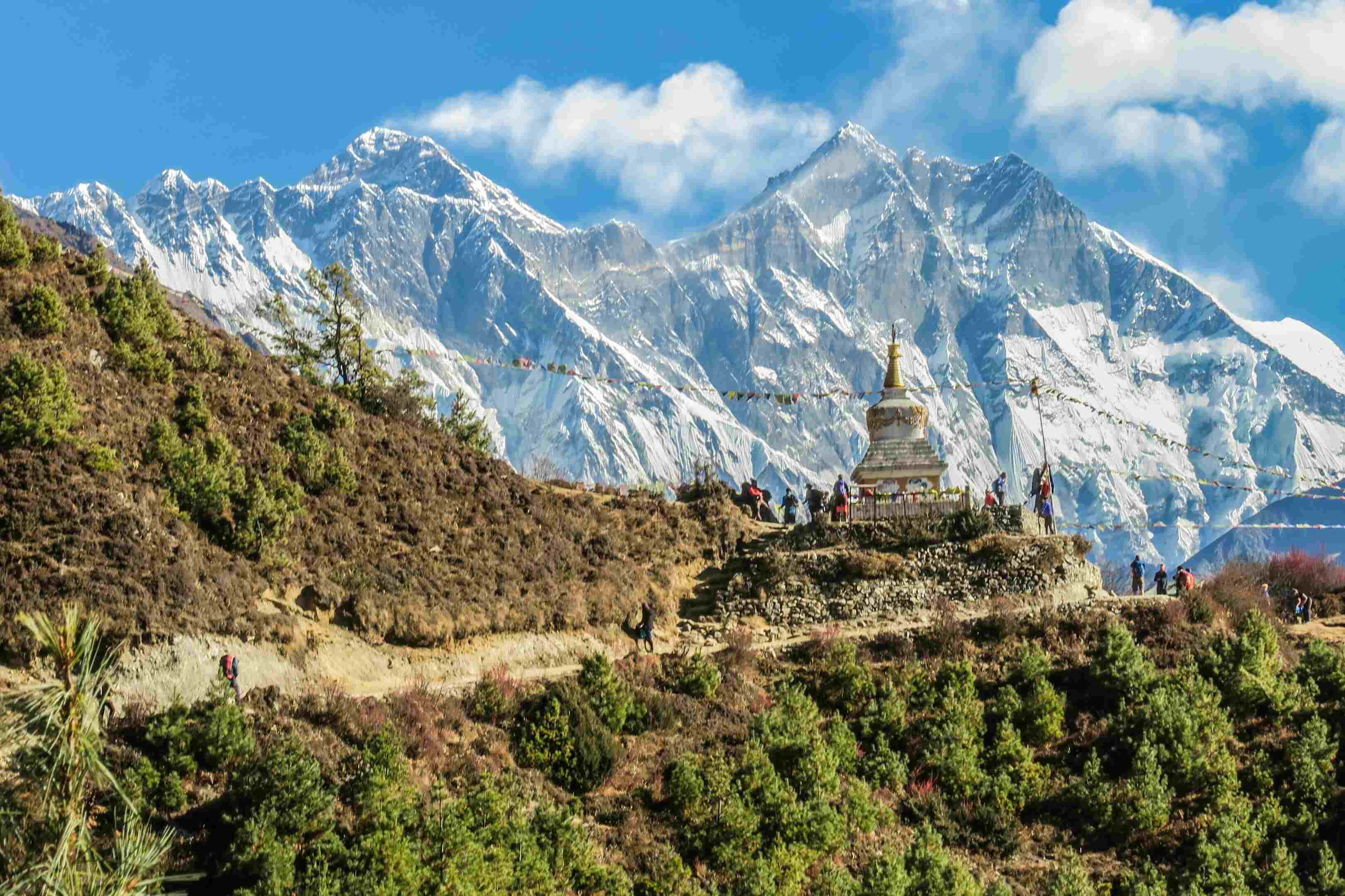
Lukla Airport, officially known as Tenzing-Hillary Airport, is one of the most remarkable yet treacherous airports in the world. Located in the Solukhumbu district of Nepal, it serves as the primary gateway for adventurers and climbers heading to Mount Everest (8,848.86 meters), the highest peak on Earth. This small yet vital airstrip is renowned for its short runway, extreme weather conditions, and high-altitude location, making it one of the most challenging places for pilots to land and take off. Despite its dangers, Lukla Airport remains the lifeline of the Everest region, facilitating tourism, commerce, and emergency rescues.
Lukla Airport was constructed in 1964 under the supervision of Sir Edmund Hillary, one of the first people to successfully summit Mount Everest in 1953, alongside Tenzing Norgay Sherpa. Before its construction, trekkers and climbers had to undertake a lengthy and grueling trek from Kathmandu to Lukla, a journey that could take several weeks.
Initially, Hillary had intended to build the airport on flat land. However, the local population was unwilling to give up fertile farmland, forcing him to construct the airport on the current sloped terrain. It is said that the ground was flattened manually with the help of local laborers, and the first few aircraft landed on a dirt runway before it was later paved.
In 2008, the airport was officially renamed Tenzing-Hillary Airport in honor of the two mountaineers who first conquered Everest. Since then, it has become a vital transit point for thousands of trekkers and mountaineers each year.
1. High-Altitude and Location
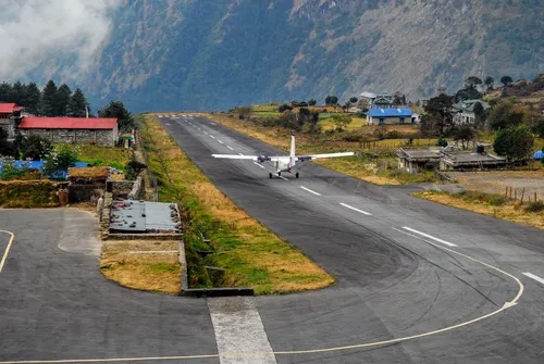
Situated at an altitude of 2,860 meters (9,383 feet), Lukla Airport is one of the highest-altitude airports in the world. The high altitude means that the air is thinner, reducing engine performance and making takeoff more challenging. Pilots must be well-trained to handle the reduced lift and quick altitude adjustments required in such conditions. Additionally, the lower oxygen levels at this altitude pose risks for passengers, often leading to altitude sickness shortly after arrival.
2. Short Runway
One of the most notable challenges of Lukla Airport is its extremely short runway, measuring only 527 meters (1,729 feet) in length and 20 meters (66 feet) in width. For comparison, an average commercial airport runway is around 3,000 meters (9,800 feet) long. The runway also has an incline of about 12 degrees, which helps slow down landing aircraft but also adds complexity to takeoffs. Additionally, the limited space for aircraft parking and maneuvering makes operations even more challenging.
3. No Go-Around Option
Unlike most commercial airports, Lukla does not provide an option for pilots to abort their landing and try again. The approach is flanked by mountains on one side and a steep drop-off on the other, meaning pilots must execute a perfect landing on the first attempt. A mistake could be fatal, as there is no space for last-minute corrections. Moreover, the absence of an air traffic control tower adds to the risks, as pilots must rely on visual cues and radio communication with ground staff.
4. Unpredictable Weather
Lukla’s weather conditions are notoriously unpredictable. Sudden changes in wind speed, fog, and cloud cover can reduce visibility to near zero. The airport frequently experiences flight delays and cancellations, as conditions may change rapidly within minutes. Pilots must rely on their experience and keen judgment when deciding whether to proceed with a flight. Furthermore, strong crosswinds and turbulent air pockets make both takeoff and landing treacherous. The airport also experiences frequent seasonal monsoons, further impacting flight reliability.
5. Limited Navigation Aids
Lukla Airport lacks advanced navigation and landing aids like an Instrument Landing System (ILS), which is standard in major airports. Pilots must depend on visual flight rules (VFR), making it nearly impossible to operate in poor visibility conditions. The lack of modern radar and automated weather monitoring further exacerbates safety concerns.
6. High Aircraft Traffic During Peak Seasons
During the spring (March-May) and autumn (September-November) trekking seasons, Lukla Airport experiences an overwhelming number of flights. The limited runway space and high number of aircraft movements increase the risk of accidents. The congestion also leads to frequent delays and increased stress for pilots and passengers alike.
Flights to and from Lukla are mainly operated by Tara Air, Summit Air, and Sita Air, using small STOL (Short Takeoff and Landing) aircraft like the DHC-6 Twin Otter and Dornier Do 228. These aircraft are specifically designed to handle short, high-altitude runways.
Most flights depart from Tribhuvan International Airport in Kathmandu, covering the 138 km (86 miles) journey to Lukla in about 25-30 minutes. However, due to congestion at Tribhuvan, flights are often rerouted to Ramechhap Airport (Manthali), about 132 km from Kathmandu, adding extra road travel for passengers.
Due to its difficult conditions, Lukla Airport has witnessed several accidents over the years. Some notable incidents include:
October 2008 – Yeti Airlines Flight 103 crashed while landing, killing 18 people. Only the pilot survived.
May 2017 – A Summit Air cargo flight overran the runway, leading to significant damage.
April 2019 – A Summit Air aircraft veered off the runway and crashed into two helicopters, killing three people.
Despite these incidents, safety measures have improved over the years. The Civil Aviation Authority of Nepal (CAAN) enforces strict weather monitoring, limited flight slots, and experienced pilot requirements to reduce risks.
For those unwilling to risk flying into Lukla, alternative trekking routes exist:
Jiri Route – The traditional Everest trekking route, starting from Jiri, takes an additional 5-7 days of trekking before reaching Lukla.
Salleri Route – A jeep ride to Salleri followed by a 3-4 day trek to Lukla offers a less risky but longer journey.
Helicopter Services – Helicopters provide an alternative but are significantly more expensive.
Lukla Airport is the economic heartbeat of the Everest region. The tourism industry, primarily trekking and mountaineering, supports thousands of local people, including guides, porters, teahouse owners, and suppliers. Without Lukla Airport, access to the Everest region would be far more difficult, drastically affecting the local economy.
Additionally, the airport serves a crucial role in emergency evacuations, helping transport climbers and trekkers who suffer from altitude sickness or injuries to Kathmandu for urgent medical care.
Future Developments and Improvements
Recognizing the challenges and importance of Lukla Airport, Nepalese authorities have proposed several improvements:
Improved Weather Forecasting Systems – Advanced radar and meteorological equipment are being introduced to enhance flight safety.
Alternative Airport Development – Plans to expand Phaplu and Manthali Airports as alternative gateways to Everest.
Better Infrastructure – Efforts to improve the airport’s air traffic management, runway quality, and aviation safety regulations.
Lukla Airport, with its high-risk landing conditions and breathtaking mountain views, remains one of the most thrilling yet dangerous airports in the world. As a vital link to Everest, it supports thousands of climbers, trekkers, and local businesses, making it an indispensable part of Nepal's tourism-driven economy. Despite the inherent risks, pilots and airlines continue to refine their skills and implement safety measures, ensuring that Lukla remains the ultimate gateway to the world’s highest peak for years to come. With ongoing improvements and increased aviation safety awareness, the airport is poised to maintain its crucial role in the Everest adventure while striving for greater reliability and security.
Categories:
Education
Tags:
LuklaAirport
,
GatewayToEverest
,
LuklaFlights
,
TenzingHillaryAirport
,
FlyToLukla
 Jul 30, 2025
Title: The Bone Trumpets of the Sky Priests: Ritual Music of Chöd Practitioners
 Jul 28, 2025
The Hidden Oracles of Mustang: The Cho-Mo Rituals
 Jul 25, 2025
“Disappearing in the Mist: The Ritual Bon Practices of Karnali Highlands”
 Jul 25, 2025
Blood, Brass, and Belief: The Fading Bronze Bell Casting Traditions of Patan